
설명
Put your stories on the map. Geolocation adds a location to your posts and shows it to your readers: as a line of text, as a link that reveals a map, or as a map. Collect your posts on an overview map, connect them to a route and add the GPX tracks of your hikes and bike tours.
Made for travel blogs, and for everyone who wants to show where a story happened. Maintained by Yann Michel since 2017.
Highlights
- A location for every post – search for an address, click on the map, drag the marker or use the position of your device. If a post has no location, the plugin reads it from the GPS data of the featured image.
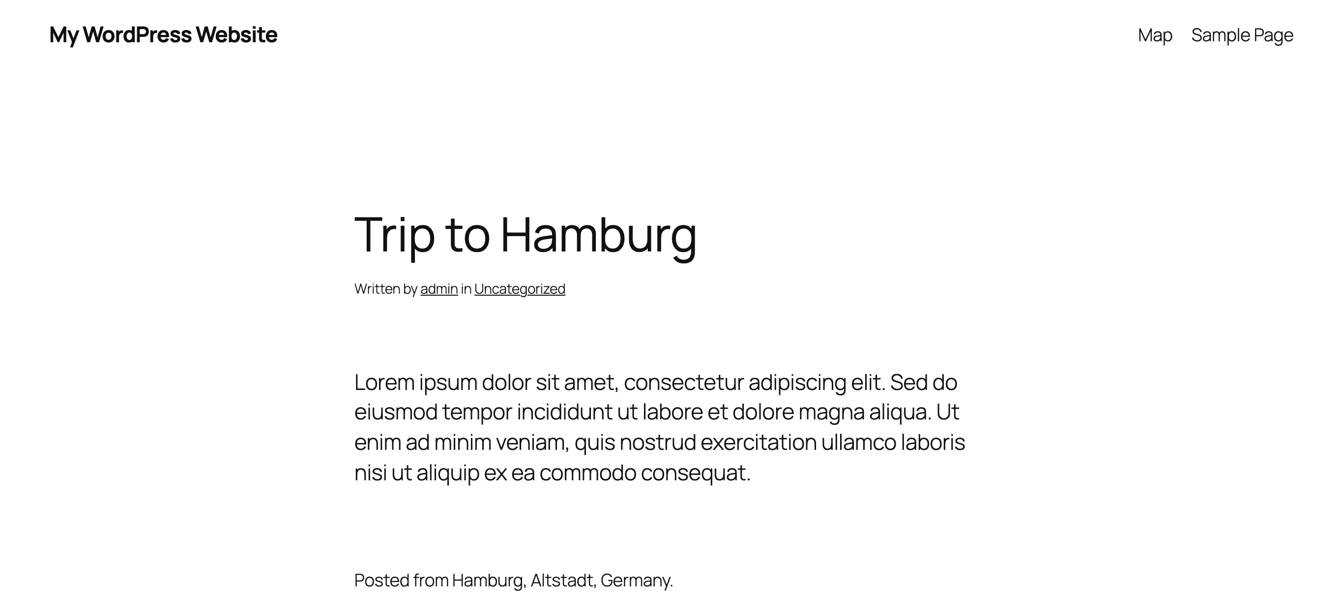
- Three ways to show it – plain text, a link that reveals a map on hover, or a map. Before the post, after it, or exactly where you place the block or the shortcode.
- Overview maps – all posts of your blog, of a category or of a tag on one map. Popups show the featured image, the date and the excerpt; markers lying close together are grouped.
- Routes and GPX tracks – connect the posts of a trip in the order they were published, and show the recorded track of a hike or a bike tour with its length, ascent, descent and elevation profile.
- Blocks and shortcode – two blocks with a live preview for the block editor, and a shortcode with attributes for everything else.
- Privacy by design – OpenStreetMap by default, map tiles from your own server, a strict mode that falls back to text, and GPX files that never leave your computer.
- Your choice of maps – OpenStreetMap or Google Maps.
- Translated – English, German, Spanish, French, Italian, Portuguese (Brazil) and Dutch.
Privacy
The plugin uses OpenStreetMap by default and delivers the map library itself. Together with the proxy plugin for OSM the map tiles come from your own server, so the browsers of your visitors do not connect to an external map server.
- The strict privacy mode only shows maps if the tiles are delivered by the proxy. Otherwise visitors see the location as text.
- The display mode plain text never loads a map for your visitors.
- Without the proxy, or with Google Maps, the tiles are loaded directly from the map service.
Locations from your photos
A post without a location takes it from the GPS data of its featured image. Two tips for photos taken with a phone:
- On an iPhone, take your photos as JPG. When a HEIC photo is converted for the upload, its GPS data is removed.
- In the WordPress app, enable the option to keep the metadata of uploaded files.
Google Maps
Google Maps needs an API key, which you get from the Google Cloud Platform. Activate the “Maps JavaScript API” and the “Geocoding API” for it.
Support
Questions, problems or ideas? Open a support request anytime, I am happy to help. If you like the plugin, a review is very welcome.
Overview maps on pages
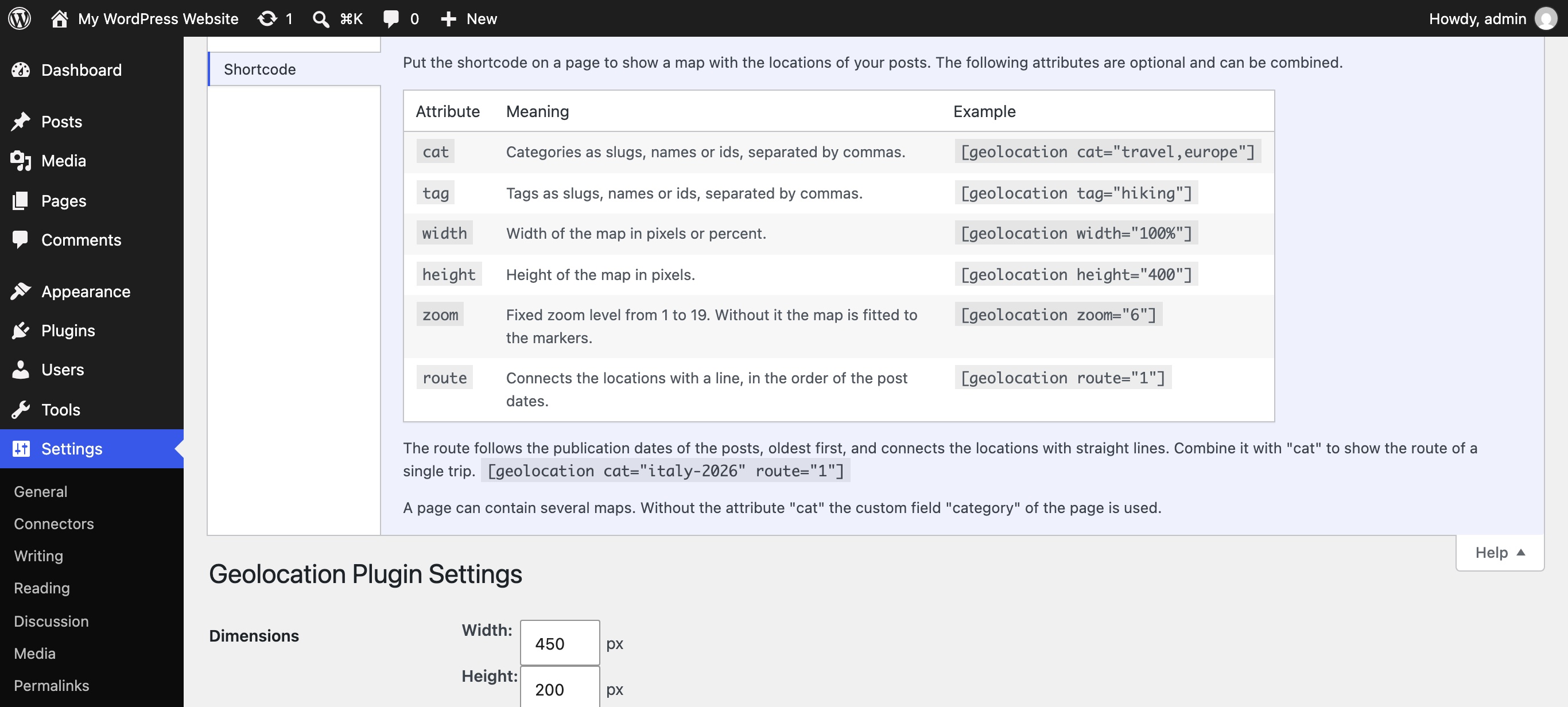
Put the shortcode on a page to show a map with the locations of your posts. Optional attributes filter the posts and set the size of the map:
cat– categories, as slugs, names or ids, separated by commas:[geolocation cat="travel,europe"]tag– tags, as slugs, names or ids, separated by commas:[geolocation tag="hiking"]width– width in pixels or percent:[geolocation width="100%"]height– height in pixels:[geolocation height="400"]zoom– a fixed zoom level from 1 to 19 instead of fitting the map to the markers:[geolocation zoom="6"]route– connects the locations with a line, in the order of the post dates:[geolocation route="1"]. Combine it withcatto show the route of a single trip:[geolocation cat="italy-2026" route="1"]
Attributes can be combined, and a page can contain several maps. Without the attribute cat the custom field “category” of the page is still used.
Tracks (GPX)
A post can carry the track of a GPX file, e.g. the recording of a hike or a bike tour. Choose the file in the Geolocation box of the post editor.
- The file is read in your browser. Only the simplified line of the track is stored with the post; the file itself, its times and elevations are not uploaded.
- With the display setting “Simple map” the map of the post shows the track; the map in the editor shows it as well.
- The post shows the key figures of the track: its length and, if the file contains elevations, ascent, descent and highest point. Below a map it also shows the elevation profile.
- An overview map with
route="1"draws the tracks as recorded and the gaps between them as dashed lines. The popup of a post shows the length of its track. - A post without a location gets the end of its track as location.
- The setting “Shorten tracks” hides a distance at the start and at the end of every track, e.g. to keep your home address private.
Block “Geolocation Map”
In the block editor you can insert the block “Geolocation Map” instead of typing the shortcode. Categories, tags, width, height, zoom and route are chosen in the settings of the block, and the editor shows the map as a preview. The block can be used in pages and posts.
Block “Post Location”
In a post the block “Post Location” shows the location of the post wherever you place it, as text, as link with a map on hover or as map with its own size. The editor shows a preview of the saved location. The automatic output before or after the post is omitted for posts using the block.
With the position setting “Not automatically” a location is only shown in posts containing the block or the shortcode. Such a post still appears on overview maps if its location is enabled and public.
스크린샷





블록
이 플러그인은 2개의 블록을 제공합니다.
- Map
- Location
설치
- Upload the
geolocationdirectory to the/wp-content/plugins/directory. (or simply install it from the official package repo) - Activate the plugin through the ‘Plugins’ menu in WordPress. In case you would want to use Google Maps, choose Google Maps as your provider and insert the Google Maps API key on the Settings > Geolocation page.
- Optionally (if you are using OSM as per default setting): Install and activate the OSM proxy to make use of local delivery without tracking options for the source to your visitors.
- Modify the display settings as needed on the Settings > Geolocation page. The chosen settings can directly be seen in the OSM preview of the settings page.
- Start posting with geolocation data.
- Leave a rating on the plugin-page. 🙂
후기


기여자 & 개발자
“Geolocation”(은)는 오픈 소스 소프트웨어입니다. 다음의 사람들이 이 플러그인에 기여하였습니다.
기여자


변경이력
1.14.0
- new: a post can carry the track of a GPX file. The file is read in the browser, only the simplified line is stored.
- new: the map of a post shows its track; an overview map with route=”1″ draws the tracks as recorded and the gaps between them as dashed lines.
- new: a post shows the key figures of its track (length, ascent, descent, highest point) and, below a map, the elevation profile.
- new: the block “Post Location” shows the location of a post wherever it is placed, with its own display mode and map size.
- new: both blocks show a live preview in the block editor.
- new: the setting “Shorten tracks” hides the start and the end of every track, e.g. to keep a home address private.
1.13.0
- new: the block “Geolocation Map” shows the overview map in the block editor without typing a shortcode; posts, size, zoom and route are chosen in the settings of the block.
1.12.0
- new: the popups on the overview map show the featured image, the date and the excerpt of a post.
- new: markers lying close together on the overview map are grouped.
- new: the shortcode of an overview map accepts the attributes cat, tag, width, height and zoom, e.g. [geolocation cat=”travel” height=”400″].
- new: the attribute route=”1″ connects the locations of an overview map with a line, in the order of the post dates.
- new: a page can contain several overview maps.
- new: the attributes are explained in the “Help” tab of the settings page.
- the settings page explains which tiles URL is in use when the proxy plugin is active.
1.11.0
- new: set the location in the editor by clicking on the map or dragging the marker (OpenStreetMap; dragging also with Google Maps).
- new: “My location” button in the editor to use the position reported by your browser.
1.10.4
- new: strict privacy mode (GDPR) for OpenStreetMap. Maps are only shown if the tiles are delivered by the proxy plugin; otherwise only the location text is shown.
- maps keep working if the tiles proxy plugin does not provide a tiles URL.
1.10.3
- added the German variants (formal, Austria, Switzerland) and completed the German translation.
- added Spanish, French, Italian, Brazilian Portuguese and Dutch translations.
1.10.2
- the support links now point to the issues of the plugin’s GitHub repository.
1.10.1
- the author link now points to the plugin’s GitHub repository.
1.10.0
- new: a location can be removed from a post in the editor.
- new: the OSM tiles and Nominatim URLs can be changed in the settings.
- scripts and styles are only loaded where a location is shown and maps are created when they scroll into view.
- addresses are cached and “update all addresses” now runs in the background.
- updated Leaflet to 1.9.4.
- fixed the city derived by Google reverse geocoding and the hemisphere of locations read from a featured image.
- multiple fixes, security hardening and compliance with the WordPress coding standards.
1.9.9
- fixing visibility
1.9.7
- fixing javascript calls and settings initialization
1.9.6
- enhancing address attribute options for OSM display of locations.
- fixing nonce array verify in case not yet filled.
1.9.5
- fixing GPS location detection from featured image.
1.9.4
- fixing unneeded call for location (thx @alexterz)
1.9.3
- fixing issue with osm reverse geocode
1.9.2
- fixing issue with page display
1.9.1
- fixing page display to also reflect ‘public’ flag accordingly: no logged in user –> only public locations; if logged in –> all locations
1.9.0
- eliminating the presence of the geo-div on non-geo pages
- removing orphaned code elements
- fixing missing div-tag for geolocation-link
- fixing ‘public’ flag functionality: if geo is switched on, a location is always shown if the flag is enabled but when it is not enabled, the geoinformation is only shown to logged in users.
- adding new display option: Simple map (static) that is always shown and not only when hovering over the link.
1.8.2
- fixing clean_coordinates
1.8.1
- fixing add_geo_support
1.8.0
- conditional load for js-libs for page and posts display (only loaded if geo data is available).
1.7.6
- extending reverse geocoding: if ‘load’ is used, the name of the location will be determinded automatically. One can overwrite the name however if updating the text-field and saving the post without re-applying the ‘load’ button.
1.7.5
- fix: skipping additional reverse geocode when saving if address is already available
- fix: lib/css usage at footer
1.7.4
- reverse geocode fixes
1.7.3
- sanitizing fixes
1.7.2
- fixing save method
1.7.1
- fixing timing for osm page display
1.7
- enabling live preview of all settings in settings panel
- fixing custom image incl. shadow, i.e, WP-pin display
- enforcing WPCS rules for this plugin
1.6
- removal of jQuery usage (vanilla JavaScript)
- reducing calls for reverseGeocode in OpenStreetMap
- embedding leaflet js and css to ommit external request to 3rd parties
- adjusting google maps scripts to reflect latest API changes
- removing orphaned js-lib
- fixing several minor bugs including code cleanup
1.5.3
- bugfix for deriving the geodata from the featured image
1.5.2
- fixing typos 🙁
1.5.1
- fixing reverseGeocode on empty address
1.5
- new function: when there is no geoinformation at a particular post, the plugin tries to receive it from the featured image gps data instead.
- code cleanup
1.4
- translations
- split funcitons by providers
- fixing zoom issue for osm when hovering over link
1.3
- code cleanup
- enhancing plugin options in install functionality
1.2
- introduce dynamic preview in settings page to directly see the effect instead of displaying fixed images
1.1.1
- bugfix for OSM urls when searching for a location or the location is reverse geocoded from lat and lon
1.1
- enabling the usage of the osm proxy Tiles Proxy for OpenStreetMap
1.0
- introducing OSM as an alternative for google maps by using leaflet-api
- for new installations, OSM is the default
- preparing readyness for osm tile proxy plugin to overcome DSGVO/GDPR tracking
0.7.4
- fixing issue with missing reset in subquery within THE_LOOP
0.7.3
- disabling unfinished osm support
0.7.2
- settings bugfix
0.7.1
- various tiny bug fixes
0.7
- code reorganization
- preparation of variable SHORTCODE
- preparation of OSM usage within plugin
- on plugin deletion, options and addresses are removed
- jQuery refrerence was fixed for compatibility with WP_DEBUG switch
0.6.2
- fixed issue in admin panel where map was not displayed
0.6.1
- code cleanup minor things
0.6.2
- fixed issue in admin panel where map was not displayed
0.6
- optimizing ‘update all Addresses’
- introducing ‘page mode’, i.e., usage of [geolocation] in a page to provide a map with multiple locations shown together
0.5.3
- fixing ‘update all Addresses’ to really process al posts providing geolocation information (and not just the first few entries).
0.5.2
- fixed bugs
- moved screenshots from plugin to asset folder (shown on description and thus not locally neccessary)
- added plugin icon 😉
0.5.1
- fixed bugs
0.5
- improved “plain” option: google-apis are no longer loaded for a visiting user but only if a backend user is logged in.
- reverse geocoding now uses the website language for the texts being shown and locally stored (also to be seen in admin panel)
- added feature to “re-run” address determination, i.e., update all geodata posts with proper address information (also respecting the language of the given site)
0.4.2
- fixing bug in saving geolocation to post_meta
0.4.1
- starting GDPR/DSGVO compliant “show only” mode without accessing any external services
- fixing http to https accesses
- fixed reverse geocoding
0.4
- visualization enhanced: display geolocation either as plain text or as simple text incl. map w/mouse over (default till now)
- since Google changed their policy and an API key is required, the plugin will now show an error message if this key is missing.
0.3.7
- re-enabled the usage without API key
0.3.6
- fixed reverse geocoding
0.3.5
- fixed default_settings
0.3.4
- fixed update hook
0.3.3
- fixed display by applying update hook
0.3.2
- fixed display
0.3.1
- fixes Google Maps API key option
- fixed Google Link
- performance/code optimizations
0.3
- introduced Google Maps API key option
- starting i18n for EN and DE
0.2.2
- code optimizations
0.2.1
- fixed some left overs from the previus release
0.2
- updated Google API calls to recent version
- taking over ownership for plugin 🙂
0.1.1
- Added ability to turn geolocation on and off for individual posts.
- Admin Panel no longer shows up when editing a page.
- Removed display of latitude and longitude on mouse hover.
- Map link color now defaults to your theme.
- Clicking map link now (properly) does nothing.
0.1
- Initial release.